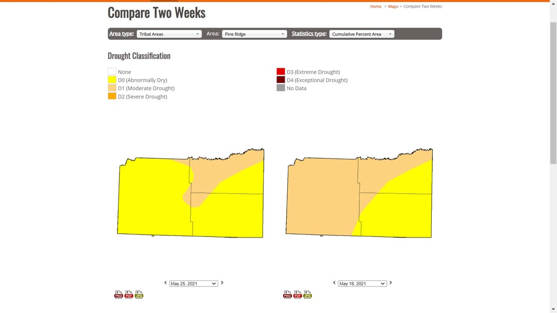
Lincoln, Neb. —Every Thursday morning, the U.S. Drought Monitor (USDM) provides the latest snapshot of evolving drought conditions across the United States and all of its territories. Along with providing a national overview of drought, the USDM website allows users to spotlight climate regions, states, USDA Climate Hubs and numerous other specified areas. Now, USDM users can also search for drought conditions for tribal areas across the country.
When you visit droughtmonitor.unl.edu and search the USDM’s numerous data and mapping products, “Tribal Areas” now appears in the dropdown menu of area types. Users can then view drought data or maps for 323 tribal areas. As with other defined territories, information and maps of the tribal areas can be cross-referenced with data from more than 20 years of USDM maps. For example, the searchable tools allow you to quickly find the highest percentage of exceptional drought that’s been recorded on the Wind River Reservation during the USDM’s history (28.3%, in January of 2003), graphs that show what percentage of the Navajo Nation is currently experiencing exceptional (D4) to extreme (D3) drought (95%, with 64% in D4) and much more.
Tribal areas are currently represented in the USDM’s map archive, data tables and time series products. The USDM change maps, which provide a week-to-week picture of where conditions improved or grew worse, will soon be available by tribal area as well.
The project to spotlight tribal area data on the U.S. Drought Monitor site is the latest effort to make the USDM more accessible to underserved populations, said National Drought Mitigation Center climatologist Brian Fuchs. A Spanish-language version of the USDM was previously created to provide weekly drought information for Spanish-speaking populations in the U.S. Both projects were completed by the National Drought Mitigation Center, housed at the University of Nebraska-Lincoln School of Natural Resources, in collaboration with the U.S. Department of Agriculture. Fuchs said it’s a goal of the USDA and NDMC to make the Drought Monitor more accessible. The USDA Office of the Chief Economist provided funding for the project.
“One of the key purposes of the U.S. Drought Monitor is to provide people with the latest information about drought conditions where they live, so that they can best respond and react to drought as it develops or lingers,” said Fuchs, who is also a Drought Monitor author. “While the Drought Monitor has been releasing information about the regions where these tribal communities are located, providing drought conditions and computing statistics for the areas within the specific boundaries of these tribal areas allows users to shine a spotlight on how drought affects these communities. The NDMC has worked with a number of tribal partners on monitoring and mitigation efforts, and providing data and mapping tools for geographically defined tribal areas has been a goal for some time. We’re grateful for the funding from the USDA to get this project done and release it for the public to use.”
Visit droughtmonitor.unl.edu to explore the new search features.
Cory Matteson, NDMC Communications